LiteStep VJ — Live DJ Visualizer
An audio-reactive, high-performance web-based VJ visualizer designed as an immersive live backdrop for DJ performances, concerts, and stage screens. Built with pure client-side HTML5 Canvas, Web Audio API, and Three.js WebGL with zero dependencies.
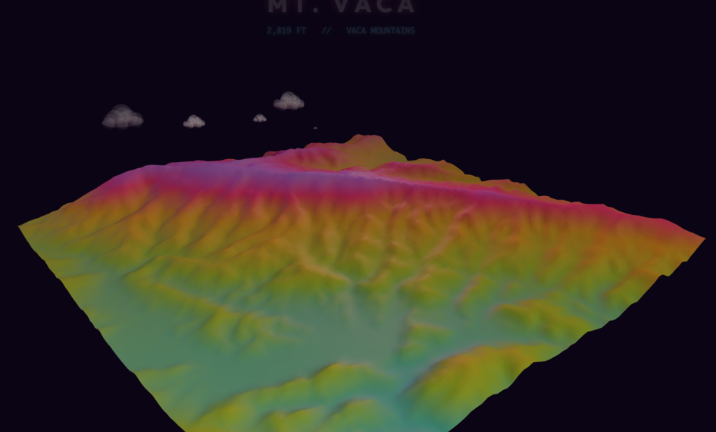
- 5 Modular Audio-Reactive Scenes: Sacred geometry mandalas, 3D topographic ridgelines (DEMs), Michel-Lévy thin-film foam, 3D cloud-swept mountains (including Mt. Vaca, Mt. Nebo & Mt. Diablo), and authentic AIST++ liquid mocap bubble dancers.
- Real-Time 4-Band Web Audio Engine: 1024-bin FFT spectrum analysis separating Sub, Bass, Mids, and Highs with kick drum transient detection and tap tempo sync.
- Rear Projection Mirror Mode: Instant GPU horizontal flip (
Xkey) for behind-screen projection setups while preserving cockpit HUD legibility. - WYSIWYG Anatomy & Choreography Studio: In-browser 3D character proportion tuner (
Pkey) with 17 choreography styles and musical power-of-2 speed scaling.
Paragliding Race Analyzer
An interactive race analyzer for competition paragliding tracklogs. Visualizes GPS trajectories, task turnpoint cylinders, start gates, thermal climbs, and speed-to-fly performance breakdowns in the browser.
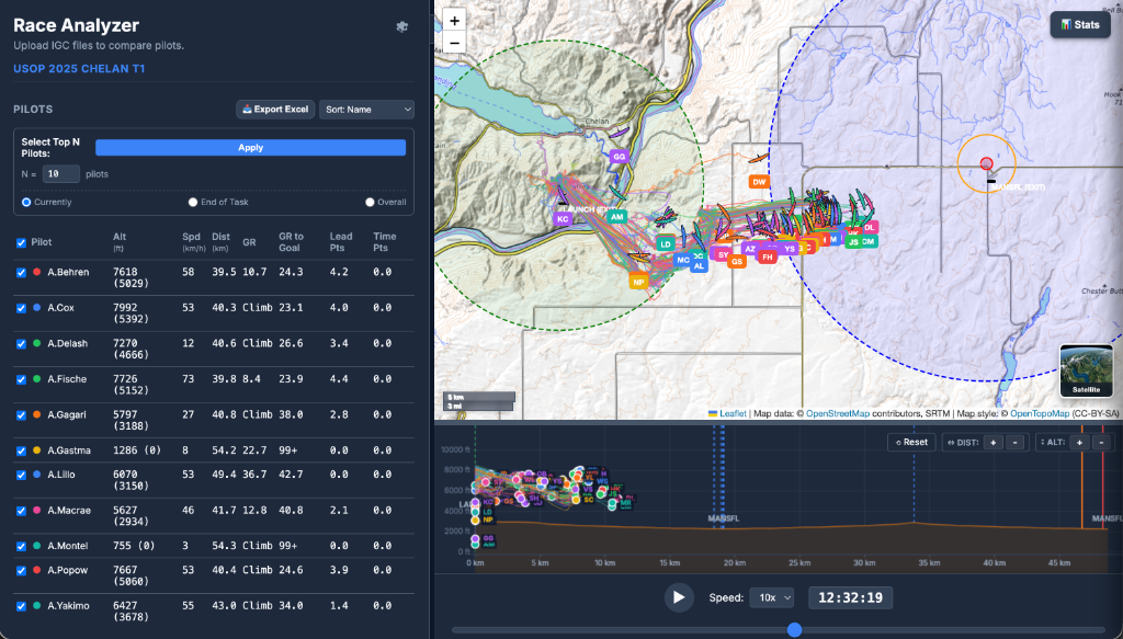
- Turnpoint & Task Breakdown: Automatic detection of turnpoint cylinder entry/exit, start gate timing, and glide speeds.
- Interactive Track Analysis: Color-coded climb rates, altitude profiles, and synchronized multi-pilot playback.
Paragliding Task Planner
A fast, offline-capable Progressive Web Application (PWA) for designing, optimizing, randomizing, and sharing competition and cross-country paragliding tasks. Features CIVL-compliant WGS-84 geodesic route optimization, interactive turnpoint cylinders, constraint-based task randomization, and instant QR code export to flight instruments.
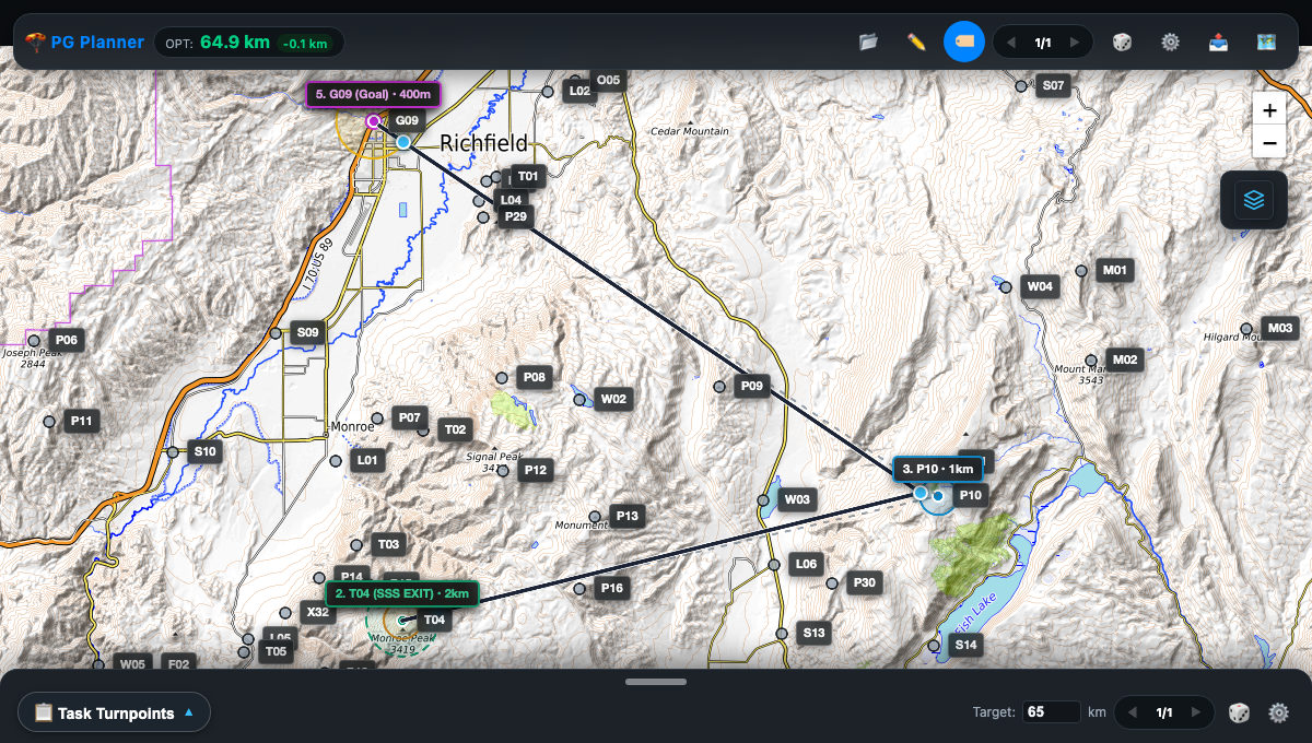
- CIVL WGS-84 Geodesic Optimization: Computes exact shortest-path routes touching all cylinder perimeters on the WGS-84 ellipsoid using high-precision Vincenty geodesic mathematics.
- Constraint-Based Task Randomizer: Multi-tier solver generates diverse competition tasks to target distance specifications while enforcing flight angles (20°–160°), minimum leg lengths, and route dissimilarity (≥ 80% unique).
- Touchpoint Route Alternatives: Click any cylinder contact point on the optimized course line to cycle through alternative catalog waypoints that maintain the identical route heading and touchpoint.
- Flight Instrument QR & Direct Export: Instant generation of compact XCTrack Format 2 (
XCTSK:...) QR codes for scanning directly from paper or screens, built-in camera QR scanner, and direct file download for.xctsk(JSON) and.cup(SeeYou) formats. - Full Offline PWA & Tile Caching: Service worker and IndexedDB area tile caching ensure complete functionality without internet on remote mountain launches.
Flight Map Studio
An interactive paragliding and hang gliding flight track visualizer and cartographic poster studio. Renders IGC GPS tracklogs over continuous 30m Digital Elevation Models (DEM) with dynamic 3D directional hillshading, customizable hypsometric color ramps, place name overlays, and high-resolution print export.
- Continuous 30m Western US DEM: Real-time client-side tile shader computing 3D NW directional hillshading and altitude palettes directly in the browser across WA, OR, CA, NV, UT, AZ, CO, and ID.
- Custom Track Styling & Analytics: Vibrant outer glow, continuous Turbo altitude gradients, climb/sink vario coloring, and individual flight color assignments.
- Place Names & Reference Overlay: Interactive opacity slider for peaks, towns, and boundaries positioned beneath flight paths.
- High-DPI Poster Studio: Multi-resolution canvas export (1×, 2×, 3×) generating framed, print-ready topographic flight posters.
Soap Bubble Surface Studio
Real-time interactive physics engine and generative surface design studio simulating 2D foam clusters, Plateau borders, and thin-film optical iridescence directly in the browser.
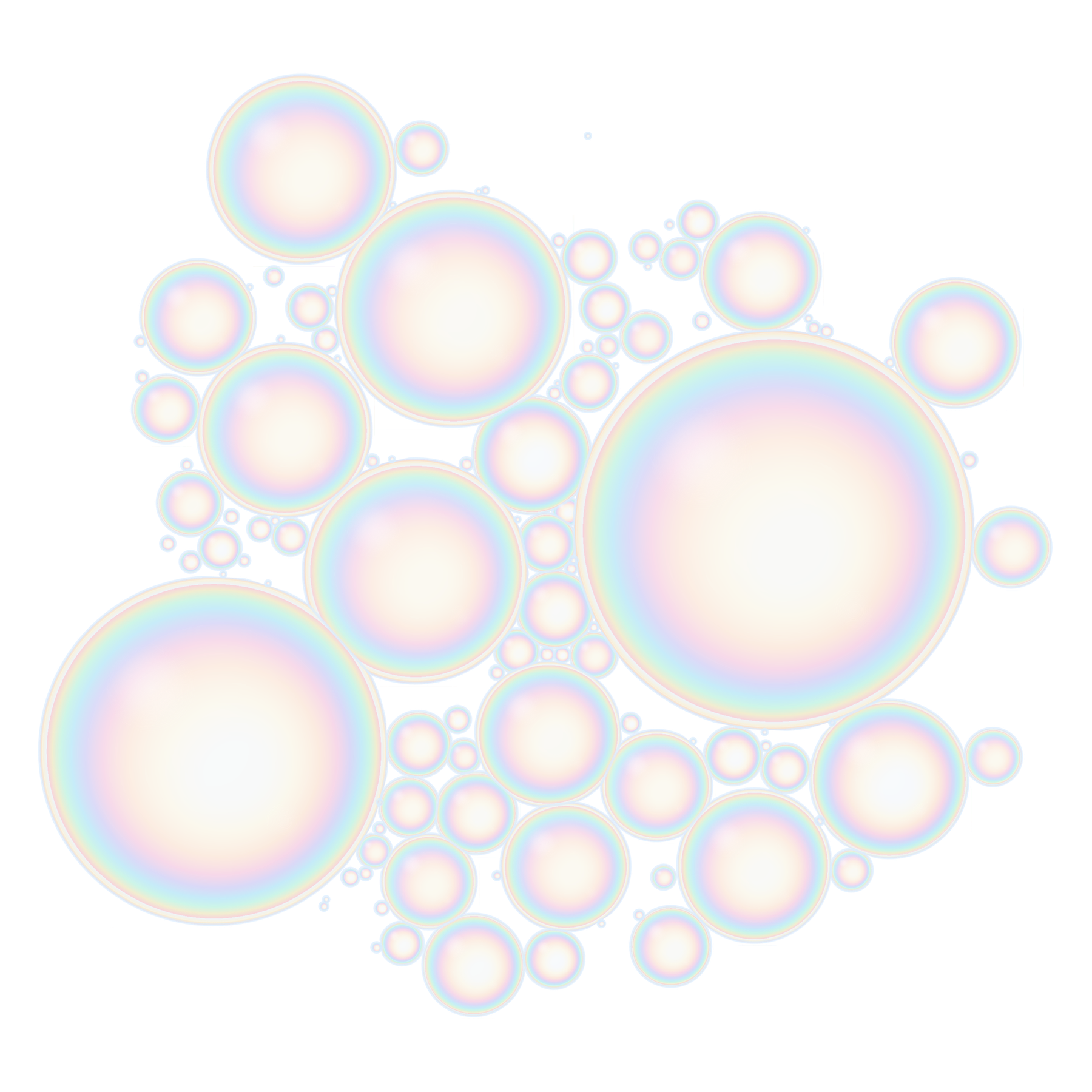
- Foam Mechanics & Plateau Laws: Dual-tier spatial hash grid calculating non-linear capillary attraction, repulsion, and 120° contact junction equilibrium at 60–120 FPS.
- Michel-Lévy Optical Iridescence: Physical thin-film interference simulation with Fresnel edge reflectance and spectral wavelength mapping.
- Interactive Fluid Tools & Audio: Swirl fluid currents, blow continuous bubble streams with a wand, pop bubbles with a needle tool, and synthesized cavity resonance audio.
- High-DPI Master Export: Vector SVG and transparent 4500×5400 PNG export ready for direct-to-garment apparel printing.
Ridgeline 3D Explorer
WebGL and 3D elevation model visualizer converting USGS Digital Elevation Model (DEM) data into customizable stacked contour lines and topographic ridgeline art for California peaks.
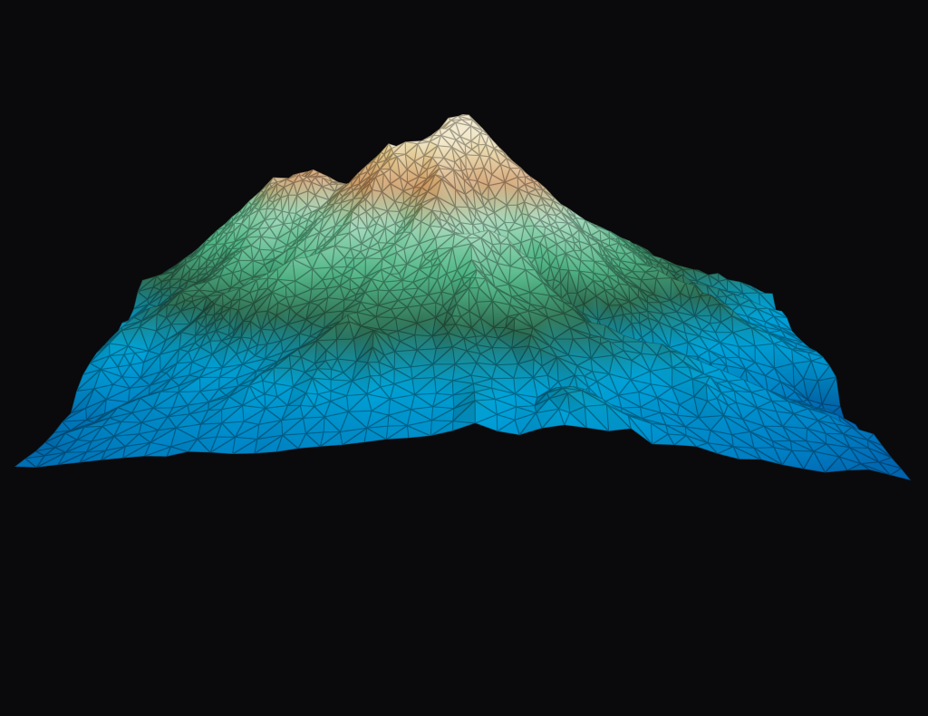
Triangulated 3D terrain mesh & heatmap elevation model

3D Ridgeline views
- 3D Mesh Controls: Dynamic vertical exaggeration, line density, perspective azimuth, and lighting angles.
- Vector Export: High-DPI export pipeline formatted for print and apparel production.
Form Constant Visualizer
Real-time procedural visualizer exploring Klüver form constants, geometric mandalas, fractal patterns, and audio-reactive harmonic symmetries directly in the browser.
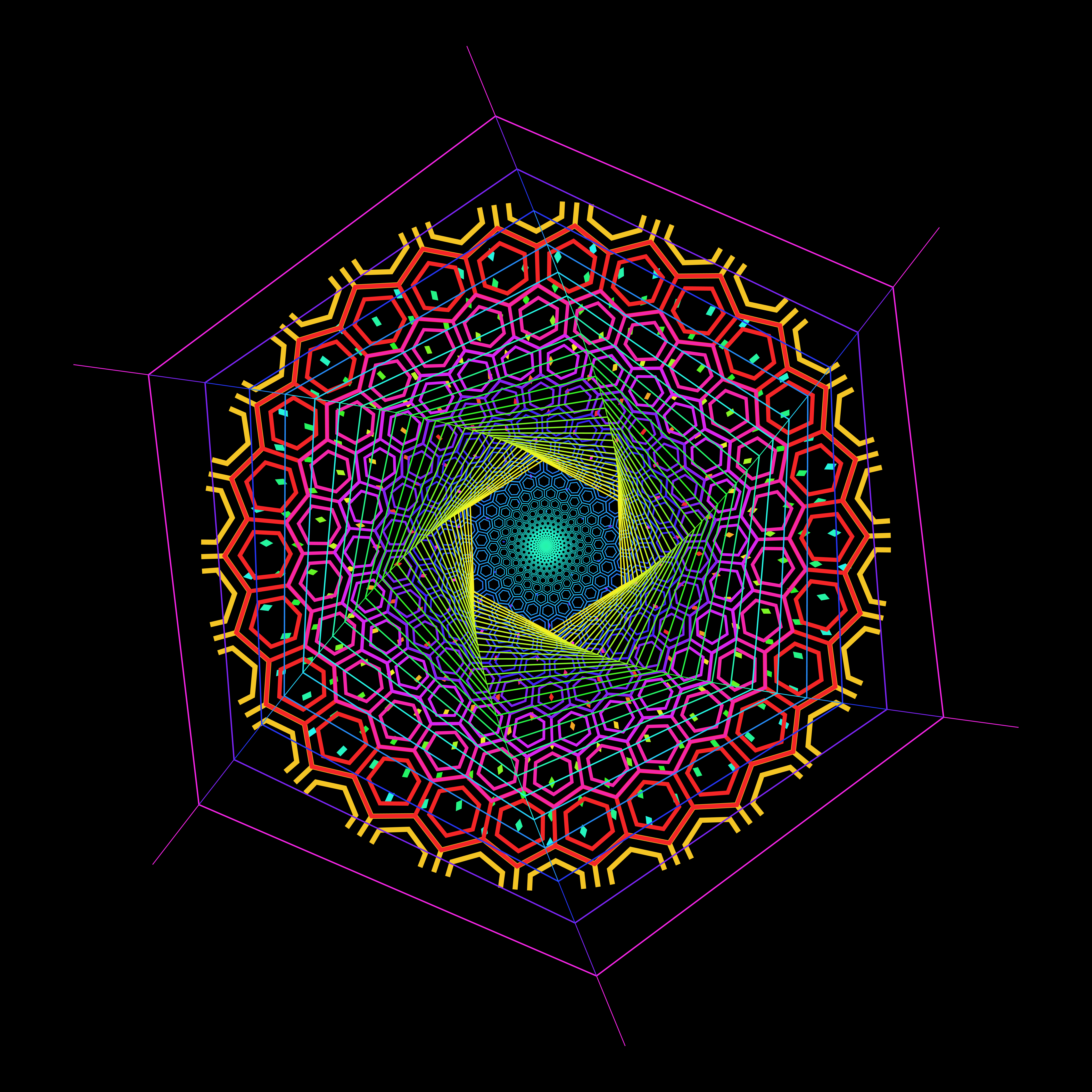
- Procedural Geometry: Interactive parameter sliders for ray counts, spiral angles, and wave frequencies.
- Audio & Kinetic Modulation: Sound-reactive animations and real-time SVG/PNG export for artwork and apparel.
Paragliding XC Simulator
An interactive cross-country flight planning and task scoring web application. Import GPS tracklogs (.IGC, .GPX, .KML) or interactively draw routes to calculate real-time XContest scoring, FAI triangle validation, and closing gap optimizations over high-resolution satellite maps.
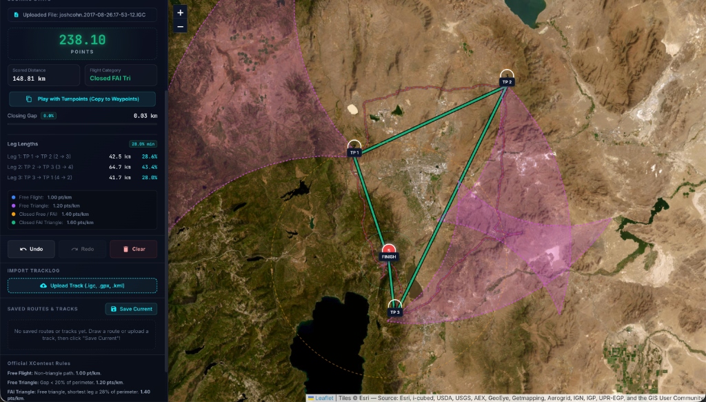
- Automatic FAI Triangle Validation: Real-time rendering of FAI turnpoint sectors ensuring shortest leg ≥ 28% perimeter constraints.
- XContest Rules & Multipliers: Live point calculation for Free Flights (1.0 pt/km), Free Triangles (1.2–1.4 pts/km), and Closed FAI Triangles (1.6 pts/km).
- Tracklog Import & Route Export: Load flight logs or design upcoming XC flights with interactive waypoints.